
Click on the sites below and explore Schoolcraft County!
Explore Schoolcraft County
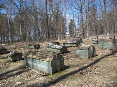
Bishop Baraga Historical Site
The Bishop Baraga Historical Site marks the approximate area where the young Catholic missionary, Reverend Frederic Baraga, established and blessed his first church on May 15, 1832. The original church building was built with the help of local Chippewa Indians, who used a traditional log and bark construction method for the chapel. In 1833, a larger chapel replaced the original, and this building possibly stood until 1873. In the early 1980s, the Indian Lake Mission was recreated on the original site. From this point, Reverend Baraga continued to minister to people in the upper Great Lakes region. He went on to become the Upper Peninsula's first Roman Catholic Bishop in 1853.
Additional Information
- This site is located off of M-94, north of Manistique. From M-94 turn west onto County Rd. P-440/Leduc Rd., travel another 31 miles or so, then turn south on Birch St. The historic site will be on the right.
- The Bishop Baraga Site is open year round to visitors.
Learn More
Imogene Herbert Historical Museum
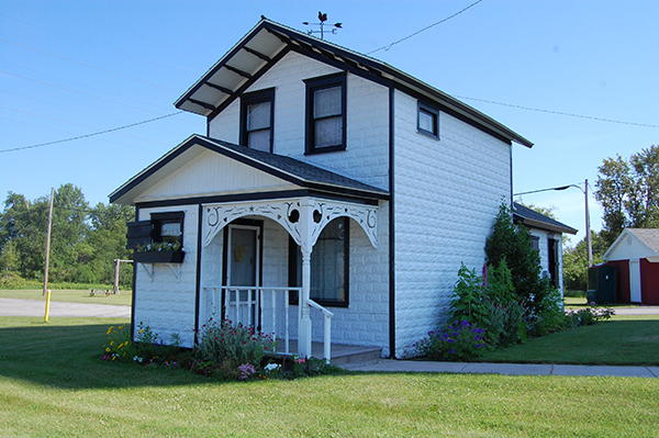
The Imogene Herbert Historical Museum, also known as the Schoolcraft County Historical Society, occupies three buildings including the Manistique Water Tower. The newly restored water tower provides space for changing exhibits as well as space for local exhibits. The small, tin sided building next door was originally built for the mother-in-law of the local pharmacist. It has since been moved to its current position and furnished in a way close to how it would have been from 1910 to 1925. The last building is the Log Cabin, originally located north of Manistique, the cabin was the home of the Alva C. Kepler family. It was built for them by colony members in 1895 and originally had two stories, it was abandoned when the Keplers moved west. It was moved to its current location in 1978 and has sense been partially restored by the Historical Society.
Additional Information
- The Historical Museum is located in Manistique on M-94/Deer Street.
- The Museum is open Wednesday through Saturday 1:00pm – 4:00pm from the last Saturday in June through the Saturday of Labor Day weekend.
Learn More
Kitch-iti-Kipi (The Big Spring)
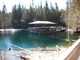
Kitch-iti-Kipi, called “The Mirror of Heaven” by early Native Americans is Michigan's largest spring. Delivering over 10,000 gallons of water per minute, this 200 foot wide, 42 foot deep spring is a wonderful sight to behold. Visitors are able to experience the springs up close on a raft which travels across the spring by a rope tow. The viewing portals allow one to see the boiling sands where the spring water erupts from underground. The crystal clear water maintains a year round 45-degree temperature and has created many native legends of love lost and true love over the centuries. When the site was discovered by Manistique businessman, John I. Bellaire, he decided that the spring should be preserved and that everyone should be able to enjoy it. In 1926, the land was purchased by the State of Michigan and was turned into a State Park, Palms Book State Park.
Additional Information
- To get to Kitch-iti-Kipi from Manistique, Michigan, travel west on US-2, after a few miles turn right (north) onto M-149 for a few miles, turning left to stay on M-149, after a mile or so, turn right onto County Road 455 for another few miles, then turn right onto M-149 (Sawmill Road) for a few more miles, there should be a sign for Kitch-iti-Kipi.
- The State Park is open daily from May 15 through September 30, but visitors may visit in the wintertime and ski or snowshoe in the park.
Learn More
- Visit the Kitch-iti-Kipi (The Big Spring) website.
- View on Google Maps
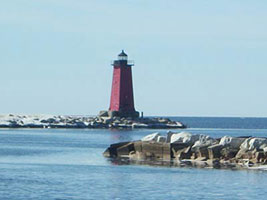
Manistique Light and Boardwalk
The Manistique Light, also known as the East Breakwater Light, is a 35 foot tall, red, square yet pyramidal like structure built in 1916, marking the harbor where the Manistique River flows into Lake Michigan. Though the light was built in 1916, its Fourth Order Fresnel Lens was first lit in 1917. The light became automated in 1969, and the lighthouse is now equipped with a 300 MM automatic beam light. The old light keeper's home, first built in 1916, is also viewable on the corner of Range Street and Washington Street. It is a white stucco duplex that is three stories high, with a red roof. The Manistique Boardwalk extends along the shore of Lake Michigan for about two miles with access to the Manistique Light on one end. The Boardwalk was built in 1991, and features interpretive signs, a pier for fishing, and many species of wildlife to enjoy while taking a leisurely stroll along Lake Michigan.
Additional Information
- The Manistique Light and Boardwalk can be entered at the Manistique Boat Marina, located at 300 South Cedar Street, Manistique, MI.
- The best times to take a stroll on the Boardwalk would be the spring, summer, and fall months.
Learn More
- Visit the Exploring Manistique, Michigan website.
- View on Google Maps
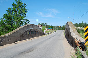
Manistique River Bridge
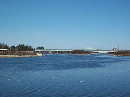
The Manistique River Bridge, also known as the Germfask Bridge, is one of the earliest constructed and longest remaining examples of the Michigan State Highway Department (MSHD) design for a long-span concrete through girder bridge with arched girders on cantilevered brackets. The MSHD first developed plans for bridges like this in 1921-22, first building one over the Raisin River at Tecumseh in 1922. In 1923, the Manistique River Bridge was built by a local contractor, Harry Erickson. The only changes made to the bridge since 1923 were guardrails which were installed at the approaches, even after about 90 years this bridge still has a high structural integrity.
Additional Information
- The Manistique River Bridge is located east of Germfask, Michigan two to five miles down Ten Curves Road/Co. Highway 498.
- This bridge can be visited all year round, though the preferred visiting time would be the late spring through fall months.
Learn More
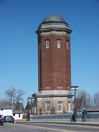
Manistique Water Tower
The Manistique Water Tower was constructed in 1922 in the Roman Revival Style. It was designed by Fridolph Danielson of Manistique and is an octagonal-shaped, domed structure made from red brick and limestone, the dome being made of copper, 25 feet in diameter and 200 feet tall. It contains a 200,000 gallon steel water tank, mainly because of a bond issue in 1920 which left the industrial, residential, and fire needs of the community lacking the water they needed. The Water Tower operated until 1966 and was abandoned in 1970. It was renovated from 2001-04 and reopened to the public in 2005.
Additional Information
- The Water Tower is located in Manistique, Michigan, on M-95/Deer Street.
- One can visit the Water Tower from the last Saturday in June through the Saturday of Labor Day weekend, open Wednesday through Saturday 1:00 pm-4:00pm.
Learn More
- Visit the Historic Manistique Water Tower website.
- View on Google Maps
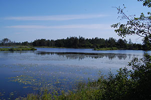
Seney National Wildlife Refuge
The Seney National Wildlife Refuge was established in 1935 for the protection and production of migratory birds and other wildlife. Before the establishment of the refuge, the Upper Peninsula had been lumbered until that was no longer possible, once the lumbering operations ceased, much of the time fires were set which damaged the organic soil. This made it very difficult for the forests to grow back on their own. Many of the sites where fires were started are still visible within the refuge today. After the fires were extinguished, a land development dug miles of drainage ditches through Seney. The land was then sold to farmers with the promise of agricultural productivity. The farms were slowly abandoned and the land returned to state ownership. In 1934, the Michigan Conservation Department recommended to the Federal Government that the area be developed as a refuge. The recommendation was accepted and the Refuge established. With the aid of the Civilian Conservation Corps and the Work Projects Administration, the land was turned into the rich marshes, swamps, bogs, grasslands, and forests perfect for wildlife.
Additional Information
- Seney is located at 1674 Refuge Entrance Rd. in Seney, Michigan.
- The Seney Visitor Center is open from mid-May through mid-October from 9 a.m. to 5 p.m. The refuge is open dawn to dusk daily.
Learn More
- Visit the Seney National Wildlife Refuge website.
- View on Google Maps
Seul Choix Point Lighthouse
The Seul Choix Point Lighthouse, pronounced Sis-Shwa and translating to "only choice" was named thus by French fur traders some time in the 1600s-1700s because it is the place they took refuge from a storm. The area around the Lighthouse has been inhabited since the early 1800s, and the Seul Choix Point Lighthouse became operational in 1892. The Lighthouse is 79 feet nine inches tall and originally contained a Third Order Fresnel lens, though it has since been replaced with a modern airport beacon lens. The Fresnel lens was originally lit and maintained by a light keeper. The keeper's house is also located on the Lighthouse grounds.
Additional Information
- To travel to Seul Choix Point Lighthouse from Gulliver, Michigan, at the junction of US-2 and County Rd 432, go south on County Rd. 432 about four miles to County Rd. 431. Turn right (west) onto County Rd. 431 (gravel road), and go about another four miles to the Lighthouse.
- The Lighthouse is open to the public, providing tours, Memorial Day through mid-October, 10:00 am – 6:00 pm, seven days a week.
Learn More
- Visit the Seul Choix Point Lighthouse Park & Museums website.
- View on Google Maps
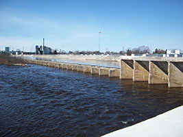
Siphon Bridge
Manistique's Siphon Bridge was originally constructed in 1919 when a solution was addressed concerning the level of water, the integrity of the river, and the newly established Manistique Pulp and Paper Company. In 1916, after the organization of the Manistique Pulp and Paper Company, engineers discovered that "a dam at the mouth of the river [that was] large enough to supply the needs of the mill would flood a large section of the city." It would also have been very expensive to build a bridge if they diked the shallow river banks. They solved their problem by building a large concrete tank lengthwise in the river bed; the sides provided artificial, higher banks to the river. Concrete bulkheads allowed the mill to maintain the water level several feet above the highway. Since the highway was below the river level, and the paper mill could maintain a steady pressure, the water from the river supported the completed bridge. For this reason, the Siphon Bridge was featured in Ripley's Believe It or Not newspaper series. Unfortunately, this unique feature has since been removed.
Additional Information
- The Siphon Bridge is located in Manistique, Michigan on U.S. Highway 2.
- One can visit the Siphon any time of year, though from the late spring to fall months is probably preferable.