
Click on the sites below and explore Iron County!
Explore Iron County
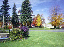
Alpha Circle Historic District
Enjoy shopping, breakfast, or lunch in the Historic Porter School, visit the Alpha Museum or take in the summer farmer's market all situated on the Alpha Circle. This wonderful example of early engineering where all the significant public buildings were constructed around a traffic circle is the forefather to the modern roundabout. Established in 1914, the same year as the village, the Alpha Circle contains several buildings on the National Register of Historic Places.
Additional Information
- Location: County Road 424, center of Village of Alpha.
- Open to the public all year.
- Call: (906) 875-6328 for more information.
Learn More
Amasa Museum
Located in the Main Street Historical District, the Amasa Museum building, formerly the township hall, is a fine example of late 1800s balloon-style architecture. The main floor has many pictorial displays of the mining and logging industries that helped build Amasa. Memorabilia include Amasa School and Triangle Ranch. An ongoing renovation of the second floor will result in a replica of "The Streets of Old Amasa." The importance of Amasa as a major hub for logging and rail transportation can be seen in the old depot that stands sturdy against time.
Additional Information
- Location: 12 miles N of US 2, just off Hwy 141 on Pine St in Amasa.
- Open Memorial Day through the summer months; winter tours by appointment. Donations welcome.
- Call: (906) 822-7714 for more information.
Learn More
Apple Blossom Trail
This non-motorized pathway along the banks of the Iron River was originally the major corridor for the rail lines that hauled thousands of tons of iron ore from local mines to the steel mills of Chicago and Indiana. See the site of Harvey Mellon's discovery of iron ore along this route in 1851, when only one settler lived here.
Additional Information
- Location: Trail Head located at the Iron County Chamber of Commerce; Access points in downtown Iron River or Caspian.
- More information: (906) 265-3822.
Learn More
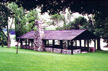
Bewabic State Park
A leisurely drive around the 315-acre state park provides an opportunity to enjoy the beautiful natural scenery of the region. Interpretive signs on the upper level near the campgrounds afford visitors a chance to see how the early settlers cleared the land for lumbering, mining, agriculture, and tourism. The park has wonderful public log buildings built by the Civilian Conservation Corps in the 1930s and includes fascinating stonework along the beach and parking lots.
Additional Information
- Location: 4 miles W of Crystal Falls on US 2.
- Open seasonally. More information: (906) 875-3324.
Learn More
- Visit the Michigan DNR Bewabic State Park website.
- View on Google Maps
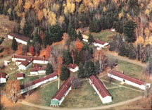
Camp Gibbs Recreation Area
This property, purchased by the US from the Michigan Mineral Land Company, was established in 1935 as Camp Gibbs, a Civilian Conservation Corps (CCC) camp. Nineteen buildings were constructed, consisting of barracks, kitchen, shower room, bakery, garages, and storage for the CCC workers. It is a unique example of vernacular American architecture of the period. The materials and methods of construction represent a time when frugality was critical to the survival of society. In the 1940s, the State of Michigan Social Welfare Commission used the camp to house indigent people from all over the state.
Additional Information
- Location: 10 miles N of US 2, about 2 miles W of Iron River.
- Open all year under a permit from the Ottawa National Forest.
Learn More
Fortune Pond
This site is a wonderful example of the many mines that have been reclaimed by nature as she heals the scars of the miner's pick. Imagine the pumps that worked 24 hours a day to keep the open pits and tunnels dry. This mine produced 1,316,905 tons of iron ore from 1953 to 1958. It had one shaft with two drifts used to drain the 210-foot deep pit. The pit is 1,930 feet long by 750 feet wide. What was once a major mining operation now lends itself to a scuba diver's and fisherman's paradise.
Additional Information
- Location: 3/4 mile N of US 2 on New Bristol Rd, 2 miles W of Crystal Falls.
- More information: (906) 265-3822.
Learn More
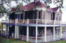
Harbour House
Explore the feeling of early life as residents in a small rural mining town. Originally built in 1900, this Queen Anne Colonial Revival home has been restored and is now a museum. The first floor furnishings and decorations reflect the craftsmanship and culture available at the turn of the century. Six rooms on the second floor display artifacts of past area influences such as logging and mining, military veterans, and the Ojibwa Indians.
Additional Information
- Location: 17 N 4th St in Crystal Falls.
- Open June 1 to Sept. 1, Tues-Sat, 10am-2pm or by appointment. Guided tours.
- More information: (906) 875-4341 or (906) 875-6026.
Learn More
- Visit the Crystal Falls Museum Society - Harbor House website.
- View on Google Maps
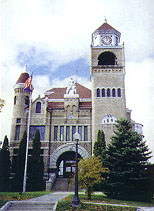
Iron County Courthouse
The wealth and pride of the pioneers are revealed through the architecture and construction of their County Courthouse. Due to the use of regional materials and the numerous and varied tributes to the area's influential cultures, this building is an accurate reflection of the days when Iron was King. Located in the Crystal Falls Historic District, it is the most architecturally significant building in the county. Restored and renovated in 2004, the site offers sightseeing tours to the bell tower observation deck. Enjoy an amazing vista of the surrounding landscape from the 150-foot bell tower while listening to its chimes. Take a self-guided tour through time in the History Room. Donations are accepted.
Additional Information
- Location: 2 S Sixth Street, at the top of the hill in Crystal Falls.
- Open Mon.-Fri. 8am-4pm. More information: (906) 875-3301.
Learn More
- Visit the Iron County Economic Chamber Alliance website.
- View on Google Maps
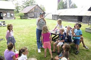
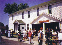
Iron County Museum
Iron County MuseumRelive the past as you explore the 10 acre indoor and outdoor museum with 26 buildings that reveal the early pioneer, mining and logging days. Plan to spend the entire day to view Iron County's largest collection of historic objects and information. Over 100 exhibits include the largest miniature logging display in the world, glass dioramas of underground mining, Native American artifacts, the home of composer Carrie Jacobs-Bond, the Wildlife Art Gallery of Lee LeBlanc and the Giovanelli Renaissance Art Gallery.
Additional Information
- Location: Drive 2 miles S of Iron River on M-189; turn E on 424 to Caspian, then left to Museum Road.
- Open June 1 to September 1, Monday - Saturday from 10 a.m. to 4 p.m. and September 2 - September 30, Monday - Saturday 12 p.m. to 4 p.m. Closed Sundays.
Learn More
- Visit the Iron County Historical Museum website.
- View on Google Maps
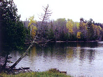
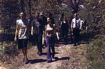
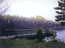
Lake Ottawa Recreation Area & Campground
A 30-minute hike to "Orville's Bench" on the Ge-Che trail (primitive) in the Ottawa National Forest will introduce you to one of the most breathtaking natural views in the county. When you return, walk along the shore of this pristine lake, which archeologists affirm contains the remnants of some of the area's earliest residents, prehistoric Indians dating back at least 2000 years.
Additional Information
- Location: 1 mile S of US 2 on M-73 to Ottawa Lake Rd, 4 miles.
- Open May 15 to Oct. 15. More information: (906) 265-5139.
Learn More
Larson Park
Imagine the trip in 1919, road engineer Herbert Larson made as he toured the area. Noting the lack of public rest areas, he became determined to provide a stop for travelers where they could relax, rest, and share information before proceeding on their journey. While not the original site, which was on Stager Lake, the State Register sign commemorates Larson's efforts here as the first roadside picnic site in Michigan and perhaps in the entire US. Explore the giant trees in the old growth birch-maple forest surrounding the site.
Additional Information
- Location: On US 2 four miles E of Iron River.
- Open May 15 to November 1.
- More information: Iron County Parks Commission at (906) 875-3301.
Learn More
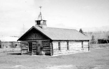
Mansfield Location and Pioneer Church
In 1893, the Michigamme River broke through and flooded the underground mine where 27 miners had descended into the dark earth tunnels never to return. Just west of the Mansfield mine disaster you can visit some of the original buildings from the community, including the Pioneer Church, which was completely restored in 1987 as a landmark and reminder of the small mining settlement. Take a stroll across the Michigamme River on the historic concrete-filled spandrel arch bridge built in 1915.
Additional Information
- Location: 7 miles N of M-69 on Mansfield Cutoff Rd, 1 mile N on Stream Rd.
- Open all year.
- More information: (906) 875-3553.
Learn More
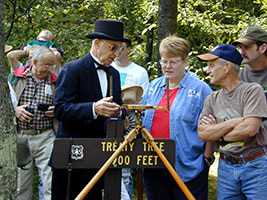
Mile Post Zero & Treaty Tree
Visit the site on the Ottawa National Forest where Captain Thomas Cram placed the first marker at the survey point establishing the Wisconsin-Michigan state boundary in 1840. As part of the settlement of the "Toledo War" between Michigan and Ohio, most of the Upper Peninsula of Michigan was granted to Michigan for the "Toledo Strip" that was granted to Ohio. Cram made a treaty for passage with Chief Ca-Sha-O-Sha and his band of Ojibwa (Chippewa) near a large tamarack tree at the headwaters of the Brule River.
Additional Information
- Location: From M-73 continue on Ottawa Lake Rd to West Brule Lake Rd to Stateline Picnic Grounds, total 7 miles.
- Open May 15-Oct. 15.
- More information: (906) 265-5139.
Learn More
Pentoga Park Indian Burial Grounds
Discover the site of a pre-European Native American settlement and permanent area headquarters where Ojibwa Bands congregated. Wooden burial structures have endured time to protect and mark the graves of these ancient bands. When Chief Edwards moved west in 1891, he disposed of these lands with their traditional burial grounds. The county purchased the land in 1924 to develop a park on the beautiful shores of Chicaugon Lake, and to preserve the burial grounds as a tribute to Native Americans.
Additional Information
- Location: County Road 424 at S end of Chicaugon Lake.
- Open 7 days 9am-8pm. Campgrounds closed during winter months.
- More information: (906) 265-3979.
Learn More
- Visit the Pentoga Park website.
- View on Google Maps