
Click on the sites below and explore Baraga County!
Explore Baraga County
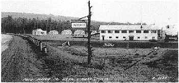
Alberta Village and Sawmill
Henry Ford built the picturesque Alberta Village in 1936 as a model self-sustaining sawmill town. He chose a site along Plumbago Creek, which he dammed. The resulting lake provided a water supply for the mill and a recreation area for the residents. One can tour the early 20th centruy sawmill and town from June 15th to October 15. You can relive the Ford dream and learn about lumbering in the western Upper Peninsula through a self-guided tour.
Additional Information
- Location: From L'Anse go south on US41 for 8 miles, approximately 5 miles north of the US41/M-28 junction.
- Knothole Gift Shop and visitor center are open year round. For additional information or to arrange group tours please call (906) 524-6181. Hours: 10 am-4pm. Closed Sundays and holidays.
Learn More
- Visit the Ford Center and Forest website.
- View on Google Maps
Arvon Slate Quarry
Only apple trees and small clearings mark the location of the townsite of Arvon. It was once home to some 300 people. Waste slate piles and a water pit remain from the Slate Mining operations that began in 1870, ending in 1892. Henry Ford pumped the water from the pit and mined slate for his operations in the 1920s. One can see the foundations of some early slate buildings, drainage ditch and piles of waste slate. The pit makes for a peaceful small lake.
Additional Information
- Location: US 41 to downtown L'Anse, at the stoplight go right (North) on Main Street which turns into Skanee Road. Go approximately 10 miles to Arvon Road and the Quarry is about 4 miles on the Arvon Road.
- Seasonal roads, but accessible year round. Please contact (906) 524-7444 for more information.
Learn More
Assinins
Assinins, from the Native language meaning "Little Stone," is named after the first Chief baptized by Father Baraga. This site is the original location of the Ojibwa Indian Mission founded by Father Baraga in 1843, and is still an active parish today. The mission was established as a Catholic mission and school just prior to Father Baraga becoming the first Bishop of Northern Michigan. This spot sits on beautiful Keweenaw Bay, and has a panoramic view of the Huron Mountain Range to the East. Baraga picked this site because of its strategic location, where he could monitor the comings and goings of the people of the day. Assinins is located on the federally recognized Indian reservation of the Keweenaw Bay Indian Community. It includes an historic schoolhouse, scenic overlook, hiking trail, and one of the UP's oldest cemeteries.
Additional Information
- Location: 2.5 miles North of the village of Baraga.
- Please contact (906) 353-6483 for additional information.
Learn More
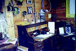
Baraga County Museum
The cedar cabin structure opened in 1995, housing a unique display of the county's past. From wooden water lines, 1800s furniture and 1000 year old Native American pottery shards, the museum gives visitors a glimpse of the historic past. The county birth and death records make it a must for genealogists. The Bishop Baraga collection, early dentist, logging and veteran's displays make it a must for all.
Additional Information
- Location: US 41 Baraga.
- Open June 1 - October 1, Monday - Saturday, 11:00am - 3:00pm. Please contact (906) 353-8444 or (906) 353-6810 for more information.
Learn More
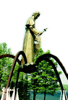
Bishop Baraga Shrine
Rising six stories above the Red Rocks Bluff, the Shrine commands a breathtaking panoramic view of Keweenaw Bay and surrounding communities. The statue of Bishop Baraga is 35 feet tall and weighs four tons, holding a cross (7 feet high) and snowshoes (26 feet long.) It floats on a cloud of stainless steel, supported by five laminated wood beams representing Baraga's five major missions.
Additional Information
- Locations: US 41 between L'Anse and Baraga, turn on to Lambert Road, follow the signs to the parking lot (less than one mile).
- Site open seven days a week, 24 hours, year round. Gift shop: Winter hours 11am - 5pm. Summer, June 15 - October 1, 9am - 6pm. Please contact (906) 524-7021 for more information.
Learn More
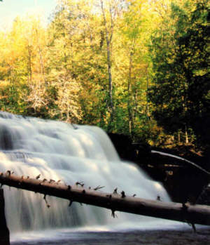
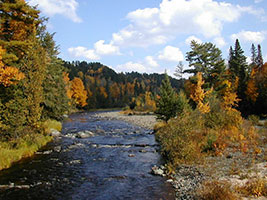
Canyon Falls
This is a beautiful box canyon waterfall and is sometimes referred to as the "Grand Canyon of the Upper Peninsula." This waterfall is located on the Sturgeon River and is part of Michigan Tech's research forest. It is unmatched for it's fury in early Spring and blazing colors in the fall.
Additional Information
- Location: From L'Anse go South on US 41 for 9 miles, approximately 4 miles North of the US 41 & M-28 junction. The trail starts in back of the water pump at the roadside park. Approximately a 10-15 minute hike on a level trail with boardwalks.
- State roadside park, summer months. Please contact (906) 524-7444 for more information.
Learn More
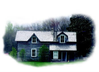
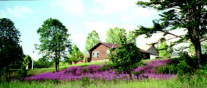
Hanka Finnish Homestead Museum
Have you ever gone down an old dirt road, through a forest, and wondered what was at the end? The road down to the Hanka Finnish Homestead Museum is just like that... Located on the original Hanka Farm, the site was homesteaded in 1886. Once located on the only road West out of Keweenaw Bay, the Hanka Farm has been restored and activated for today's visitor enjoyment. The Finnish immigrant farm museum opened in 1985 and is operated by volunteers. The museum is a reminder to visitors and local residents of our early settlement heritage.
Additional Information
- Location: Follow signs from US 41 or corner of M-38 & Pelkie Road. The Hanka Homestead is located well of the beaten path in its original setting. Don't panic; enjoy the scenic drive on the back roads.
- Please contact (906) 524-7444 for more information.
Learn More
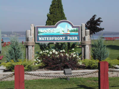
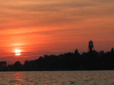
L'Anse Waterfront and Township Hall
The waterfront has sidewalks along the shoreline, picnic tables, pavilion, and restrooms. You will also enjoy some of the historic artifacts that are on display. There are barrier free fishing platforms. You may order your take-out meals from nearby restaurants or enjoy your picnic lunch. You will see the Township Hall and may walk there to see a large collection of historic photography that the township maintains for public viewing during regular office hours.
Additional Information
- Location: US 41 to downtown L'Anse waterfront.
- There is a large public parking lot including room for vehicles with trailers. Park open all of the time. Township Hall photos available during normal office hours: 9:00am - 12:00pm and 1:00pm -3:00pm weekdays (except holidays.) Please contact (906) 524-7377 for more information.
Learn More
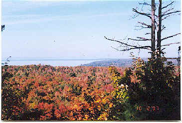
Little Mountain
When you reach the top of Little Mountain there is a panoramic view of Keweenaw Bay and the Huron Mountains. The scenic view changes with the seasons as an artist paints the horizon.
Additional Information
- Location: From L'Anse go South on US 41 approximately 2 miles. North of US 41 & M-28 junction 9 - 10 miles. Take Golf Course Road 2 miles to the Trail's Head. Hike is approximately 25 minutes.
- Open weather permitting. Please contact (906) 524-7444 for more information.
Learn More
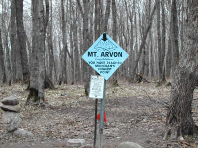
Mount Avron
For years, Mount Curwood was thought to be Michigan's highest peak. In 1982 the U.S. Department of Interior's survey team gathered new measurements. Mount Curwood is 1978.24 feet and Mount Arvon is 1979.238 feet above sea level. Although no panoramic view is offered from the summit of Mount Arvon, visitors can enjoy unspoiled forest scenery.
Additional Information
- Location: US 41 to downtown L'Anse. Turn right (North) at the four way stop on Main Street, which will turn into Skanee Road. Go approximately 16 miles to Roland Lake Road, turn right and go 3 miles to Ravine River Road. Go 8 miles and follow the blue diamond shaped signs that mark the way to the summit.
- Seasonal road, but accessible in the winter by snowmobile. Please contact (906) 524-7444 for more information.
Learn More
Pequaming
Henry Ford bought the town from Hebbard's Logging in 1924. The town was built on the site of a former Indian Settlement. The location was the site of the first Baraga County Church as Father Menard spent the winter of 1660-1661 at this settlement. You may see the former Ford sawmill, Ford bungalow, and historic cemetery. The town sites are all privately owned. A drive through of the village settlement is open year round.
Additional Information
- Location: US 41 to downtown L'Anse through the stoplight to the waterfront. Turn North on Bayshore Drive, 7 miles to this former Henry Ford sawmill town.
- A drive through of the village settlement is open year round. Please contact (906) 524-7444 for more information.
Learn More
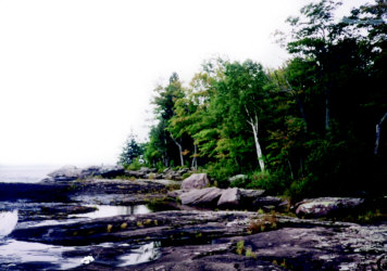
Point Abbaye
A picturesque wilderness has an unmatched view of the Huron Islands and the Huron Mountains, along with the crystal clear waters of Lake Superior. Enjoy the serenity of nature at this remote area which has been unspoiled by human development
Additional Information
- Location: US 41 to downtown L'Anse. Turn right (North) at the four way stop on Main Street, which will turn into Skanee Road. Go approximately 8 miles and turn left on Townline Road. Go 4 miles to a stop sign: go straight for another mile; turn right on Point Abbaye Road. Go approximately 7 - 8 miles and you will have reached the Point.
- Seasonal road, but accessible year round. Please contact (906) 524-7444 for more information.
Learn More
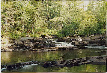
Sturgeon River Falls and Gorge
This unique geological and distinctive landform is not to be found in any other area of the Lake States. Volcanic rock outcrops form the 20-foot Sturgeon Falls and the 300 foot deep river erosion creates the breathtaking Gorge. This wilderness site will challenge your mind and endurance, a most refreshing "get away from it all location." This scenic and challenging area is found in the Ottawa National Forest. A wilderness experience for those who want to fish, backpack, canoe, kayak, or camp.
Additional Information
- Location: West from Baraga on M-38 to Prickett Dam Road, 8 miles, South on the Prickett Dam Road (pass the dam, boat launch and Silver Mountain,) cross the bridge, 6 miles, and Sturgeon River to Trail Head parking lot on Forest Road 2270, (3 miles). From Sidnaw on M-28, North on Forest Road 2200 to junction of Forest Road 2270. Parking lot is 1/2 mile from junction.
- Seasonal roads may have barriers due to seasonal snow quantities, but normally accessible year round. Please contact (906) 524-7444 for more information.