Chippewa County
Click on the sites below and explore Chippewa County!
Camp Raco
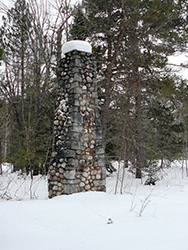 Known as the "Lone Pine Camp," Camp Raco was founded on May 2, 1933 as the first Civilian Conservation Camp in the Upper Peninsula. The CCC was a program created by President Franklin D. Roosevelt's New Deal to provide employment for unemployed and troubled young men, who worked on public facilities projects in national parks and forests. Camp Raco was home to company 667, composed of young men from Detroit and Hamtramck. Over the next 9 years, the men at the camp planted trees, constructed trails, planted fish, constructed campgrounds and assisted with fire suppression for over 150,000 acres. In 1942, the CCC was phased out with America's entry into the Second World War. However, soon afterwards, Camp Raco was converted into a camp for over 250 German prisoners of war. Today, the only remaining remnant of the camp is a chimney from one of the camp buildings.
Additional Information
It is located South of M-28 at its junction with FR- 3154 just east of the village of Raco. The coordinates for the site are: N 46° 22.009 W 084° 44.328. View Map
For more information, visit this website.
Chippewa County Historical Society
The Chippewa County Historical Society is located in the historic News Building, built in 1889. This building housed the offices of The Sault News, owned by Chase S. Osborn's (Governor of Michigan, 1911-1913). Today this Romanesque-style building is at the heart of Sault Ste. Marie's historic district and is a great place to begin one's visit all of the sites. Besides featuring permanent and temporary displays on the history of the county, the CCHS has an extensive research archives and gift shop with books on the local history. They also have brochures on the local sites to help you with your visit.
Additional Information
It is located at 115 Ashmun Street in Sault Ste. Marie.View Map
The CCHS is open year round.
Detour Light
Guiding ships along the Northwest coast of Lake Huron since 1847, the DeTour Light has long been considered to "Gateway to Superior" by mariners entering the DeTour Channel. Originally the light was on the mainland at Point DeTour but was moved to the middle of the reef off the coast in 1931 to assist ships with navigating this tricky passage. The light was maintained by a lighthouse keeper until 1974, when it was automated and it eventually was considered excess property by the U.S. Government. Declared one of the National Trust for Historic Preservations most endangered structures, the non-profit DeTour Reef Light Preservation Society, took over the management and preservation of the light in 1998. Since that time it has made great strides in preserving and interpreting this historical lighthouse, restoring it in 2003-2004 to its original 1931 appearance.
Additional Information
Tours of the lighthouse are given in the summer by the DRLPS. For more information go to their website.
Drummond Island Historical Museum
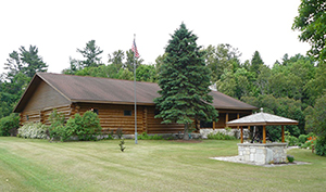 Located in Drummond Village, about 10 miles from the ferry to Drummond Island, this museum features hundreds of artifacts and photographs related to over 2,000 years of the island's history. The museum was built on the site where early settler Daniel Murray Seaman built his home in 1853 (the Seamans' are the oldest remaining family on the island). The foundation of the home is visible in the garden in front of the museum. The museum itself features a wide array of artifacts, including items from the lumbering period, the Finnish settlement of the island, a miniature model of the English fort, Fort Drummond and lots of other interesting items. There are also historical files and photographs which can be accessed with the assistance of the Museums enthusiastic and helpful volunteer staff.
Additional Information
The Museum is located in Drummond Village, about 10 miles from the ferry to Drummond Island. View Map
Open from Memorial Day through mid-October 1p.m. to 5p.m.daily.For more information go to their website.
Finn Hall, Sugar Island
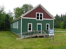 In the 1910s and 1920s, a large number of Finnish immigrants began settling on Sugar Island to take advantage of the cheap available land for agriculture. Most did not come directly from Finland but had lived and worked in the mines of the Western Upper Peninsula and other parts of the Midwest and Canada. By the 1930s, the Finns had become an important fixture on the culture of the island. In 1925, the Finnish community built a social hall (known as the Finn Hall) at the corner of 6 ½ mile road and Homestead Rd. Here there were frequent dances where the best Finnish musicians in the region would perform. However, like many Finn halls across the Upper Peninsula, it eventually was no longer used and fell into disrepair. In 2005, the Sugar Island Historical Preservation Society began repairing the Finn Hall and are slowing returning it to its original state. The organization holds concerts and annual events at the site in the summer time.
Additional Information
For more information on the site, call George Snider at 906-632-1772 or e-mailgeosnider@yahoo.com.
Holy Angels Church and Cemetery, Sugar Island
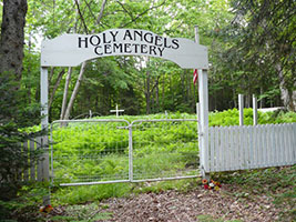 Along the north shore of Sugar Island is the small settlement of Payment. It was in 1857, that the founder of community, Michael Payment, built Holy Angels Church. It was built at the request of Bishop Frederic Baraga, first bishop of the Diocese of Sault Ste. Marie (later Marquette), who had been running a mission on the site of the Church from 1853 - 1864. The church remained open for general services until 1953. It was later reopened for summer services in the 1980s. The church is maintained by the Sugar Island Historical Preservation Society and does not have regularly open hours. It is one of the oldest church structures still standing in the Upper Peninsula. Behind the church is a wooded trail that leads up to the parish cemetery. This beautiful cemetery is part of the forest and has many old stones and wooden crosses which are tied to the Anishinaabeg community of Payment.
Additional Information
For more information on the site, call George Snider at 906-632-1772 or e-mailgeosnider@yahoo.com.
Lime Island
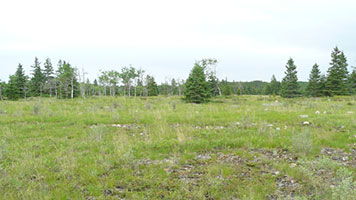 On the north end of Drummond Island is a rare and fascinating Alvar landscape known as the Maxton Plains. An alvar is a limestone plain that has very little or no top soil, so there is very little vegetation except for grasses and different types of lichen or mosses. It is created by the soil being scraped away by wind, rain, and floods over thousands of years. This type of landscape provides home for a unique blend of flora and fauna, including 10 of Michigan's rarest plants. Alvar landscapes are rare in North America and can only be found in sparsely in Ohio, New York, Quebec, Ontario and Manitoba, in addition to Drummond Island. Because of the fragile and rare nature of this landscape, it must be explored by foot. Motorized vehicles and bicycles are not allowed in the preserve.
Additional Information
For more information on the site go to this website.
Pt. Iroquois Lighthouse
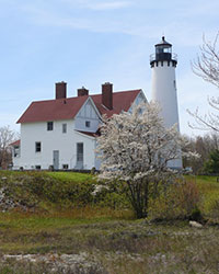 Standing along the shore of one of America's oldest navigated waterways, the
Pt. Iroquois Lighthouse has guided mariners and their vessels to the St.
Mary's River for over 140 years. With the opening of the Soo Locks in 1855,
there was a greater need for a lighthouse to help iron ore vessels to the
headwaters of the river. The first lighthouse on this site was a stone and
wooden structure built in 1855, with the first light being lit in 1857. In
1870, the current lighthouse and other structures were built and served
shipping for 92 years. The lighthouse is now a historic site maintained by
the U.S. Forest Service and is open to the public. Visitors can climb up to
the top of the lighthouse's 65 foot tower and a museum that tells the
history of the lighthouse and the lives of the people who maintained it from
1870 to 1977.
Additional Information
For more information visit,https://www.fs.usda.gov/wps/portal/fsinternet/.
Soo Locks - Sault Ste. Marie
An engineering marvel and popular destination, the Soo Locks are famous the world over as being the busiest shipping lock on the planet. Its importance to the history of the United States, however, has often been overshadowed by its pure majesty. The original lock at this site opened in 1855 made possible the shipping of the Upper Peninsula's great riches in copper and iron ore to the great manufacturing cities of the Midwest, contributing to the Industrial Revolution in the United States. Over the past 155 years, the locks has brought not only fed the crucible of industry but also help feed the world by provided transport of grain and other agricultural products from America's breadbasket. In 1895, the Poe Lock was built at it's current location along the St. Mary's River rapids and over the next 50 years was expanded to four locks. Visitors today can see ships passing through the locks daily in two large observation decks. In addition, the locks has a visitor center and many interesting artifacts and sculpting throughout its grounds.
Additional Information
For more information visit,https://www.saultstemarie.com/soo-locks-46/.
Water Street Historic Block - Sault Ste. Marie
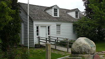 Water Street is one of the most historic streets in the Upper Peninsula. There are several historic structures and sites along the street, some of which predate the street itself. The historic buildings located along the block include the John Johnston House, home of the noted Scottish fur trader; the Henry Rowe Schoolcraft House, which was the home of the famous ethnographer, author and Indian Agent for the Michigan Territory and also the Bishop Baraga House, which was the home of the founding bishop of the Sault Ste. Marie Diocese (now Marquette Diocese). Here is a link with more information on these individuals sites. In addition to the historic homes, just down the block is the site of Fort Brady, which served as the main U.S. military installation along the St. Mary's River from 1822 to the 1890s. It was actually built on the same site as the original French French Fort Repentigny. Adjacent to the fort grounds is a burial ground with several Anishinaabeg spirit houses. These grounds are not open to the public.
Additional Information
Whitefish Point
One of the most important points of navigation along the southern shore of Lake Superior, Whitefish Point Light Station was created in 1847 by the U.S. Congress. Today, the site is managed by the Great Lakes Shipwreck Historical Association and includes not only the lighthouse station but also the Great Lakes Shipwreck Museum. The current lighthouse was built in 1861 and is the oldest operating lighthouse on Lake Superior. This shoreline has long been a graveyard for sailing vessels due to the dangerous waters of Lake Supeior, most famously the Edmund Fitzgerald which sank only 15 miles northwest of Whitefish Point. The Museum features exhibits on shipping along Lake Superior and the many vessels that still lie at the bottom of Lake Superior. The museum is open daily from May 1st to October 31st. There is also an active slate of public programs.
Additional Information
- <
For more info, go towww.shipwreckmuseum.com.


